Trail Touring skiing Le Grand-Bornand - Tête des Annes en ski de randonnée - Photo

Tête des Annes en ski de randonnée

 Chabard
Chabard

User

© OpenStreetMap contributors
Length
Length
15.8 km
Max alt
Max alt
1859 m
Uphill gradient
Uphill gradient
1021 m
Km-Effort
Km-Effort  
29 km
Min alt
Min alt
1303 m
Downhill gradient
Downhill gradient
1019 m
Boucle
Boucle
Yes
Creation date :
2024-02-24 07:25:54.0
Updated on :
2024-02-24 14:48:16.013

(0 Reviews)

Touring skiing
Touring skiing
5h28
Difficulty : Difficult

Scan this QR Code to open this trail in the SityTrail application

FREE GPS app for hiking

Logo SityTrail SityTrail

IGN / Geographical institutes

Download SityTrail from the App Store Download SityTrail from Google Play

Logo SityTrail SityTrail Plus

The world is yours!

Download SityTrail from the App Store Download SityTrail from Google Play Download SityTrail on Huawei AppGallery

About

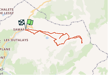
Trail Touring skiing of 15.8 km to be discovered at Auvergne-Rhône-Alpes, Upper Savoy, Le Grand-Bornand. This trail is proposed by Chabard.

Description

Départ du Chinaillon.
Montée à la Clef des Annes.
Descente sur la vallée de la Duche.
Remontée jusqu'au Col des Annes puis jusqu'à la Tête des Annes.
Descente jusqu'à la Chapelle de la Duche.
Remontée sur la crête par Le Vacheret.
Descente par les pistes sur le Chinaillon.

Elevation profile

Positioning

Country:
France
Region :
Auvergne-Rhône-Alpes
Department/Province :
Upper Savoy
Municipality :
Le Grand-Bornand
Location:
Unknown
Start:(UTM)
303424 ; 5094481 (32T) N.


Close
My subscriptions